1. What It Is (Concept)
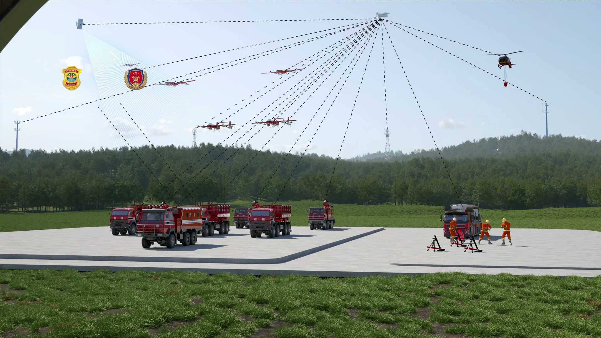
Q1. What is the Air-Space-Ground FireGuard system? The Air-Space-Ground FireGuard system is an integrated wildfire management platform that combines satellite remote sensing (space), drone fleets (aerial), ground vehicles and observation towers (ground) into one closed-loop command architecture. It consists of four layers:
-
Space segment: BeiDou-3 and remote-sensing satellites for wide-area macro monitoring, global positioning, and emergency short-message communication that does not rely on public networks.
-
Aerial segment: Long-endurance reconnaissance drones and heavy-payload firefighting drones for close-range patrol early warning, fire-scene mapping, and aerial suppression drops.
-
Ground mobile segment: Intelligent command vehicles, cluster rocket launcher vehicles, and integrated supply vehicles for command & dispatch, long-range suppression, and logistics support.
-
Ground fixed segment: Forest watchtower panoramic electro-optical AI smoke/fire recognition terminals for continuous fixed-point monitoring. A three-layer composite communication system (5G public network + MESH ad-hoc network + satellite short messages) and an AI command & dispatch software suite drive the full "detect – decide – dispatch – assess" cycle, compressing it to the minute level. The core value is to detect earlier, decide faster, and fight fires as a system.
Q2. Why do you need an integrated space-air-ground approach instead of a single solution? Every single detection method has blind spots, meaning a single approach cannot simultaneously meet the requirements of broad coverage, clear visibility, and rapid response.
-
Satellites: Broad coverage, but long revisit cycles and limited spatial resolution—suitable for macro fire-point screening, but unable to meet the minute-level requirements for "early detection".
-
Watchtowers: Affected by terrain occlusion and weather; performance drops sharply at night and in adverse conditions, and they cannot automatically recognize early small fires.
-
Ground patrols: High labor costs and slow response speeds make it difficult to cover vast forest areas. The space-air-ground approach solves this through layered complementarity: satellites screen wide areas, ground towers and drones perform near-field precision detection, and AI automatically recognizes smoke and fire. In this system, near-field smoke/fire recognition takes ≤5 seconds, coordinate calculation takes ≤1 second, and the fire false-alarm rate is ≤0.3%, turning "early detection and rapid response" into measurable system capabilities.
2. How It Works (Process & Technology)
Q3. What is the end-to-end response flow, and how fast is it? The system follows a closed loop of "detect → decide → dispatch → assess", with an end-to-end time of approximately 14 seconds from fire recognition to the first dispatch instruction.
-
Detect: Satellite wide-area screening + AI smoke/fire recognition on watchtowers and drone electro-optical gimbals (≤5 seconds), automatically locking onto the fire and outputting geographic coordinates (coordinate calculation ≤1 second).
-
Decide: The command vehicle dispatches reconnaissance drones to review the fire scene, while AI comprehensively analyzes the fire's location, area, intensity, and surroundings to generate an optimal suppression plan (≤5 seconds) and issue instructions to combat units (≤4 seconds).
-
Dispatch: Firefighting drones execute aerial drops, cluster rocket launcher vehicles execute remote suppression, and multiple drones and vehicles coordinate across different zones.
-
Assess: AI evaluates suppression results and plans follow-up drops and residual fire clearance. In travel-time terms: a fully loaded drone flying at full speed reaches a fire in approximately 18 minutes at a 30 km range, and about 60 minutes at the 100 km extreme radius. Patrol radii can be configured based on forest area and fire risk levels.
Q4. How does AI-based smoke and fire detection work, and how accurate is it? The system runs machine-learning smoke/fire recognition models that analyze multiple live video streams from electro-optical gimbals and watchtowers. By comparing dynamic feature templates of flame texture and smoke color, it distinguishes interference sources such as fog, sunlight, and dust to lock onto fire points and output geographic coordinates.
-
Speed: Smoke/fire recognition ≤5 seconds, coordinate calculation ≤1 second.
-
Accuracy: Fire false-alarm rate ≤0.3%, equipped with a 5-minute AI secondary review mechanism that automatically rules out false alarms.
-
Local training: The software reserves an interface for local sample dataset imports, allowing models to be optimized using regional vegetation, terrain, and historical fire samples to adapt to different mountain and forest conditions.
-
Algorithm composition: Convolutional smoke/fire image recognition algorithms, fire-spread prediction models, firefighting resource dispatch algorithms, and fire-control trajectory calculation models, all running on a domestic Linux industrial computing platform (developed in C++).
Q5. How does the system communicate in remote areas without cellular coverage? The system uses a three-layer composite communication architecture—"5G first, MESH ad-hoc backup, BeiDou short-message fallback"—ensuring the command link remains active even without public networks.
-
With public networks: 5G links handle large data transmissions like high-definition video.
-
Without public networks: The command vehicle deploys a tethered balloon or relay drone to form a centerless distributed MESH ad-hoc network. All vehicles and drones interconnect point-to-point, with aerial relay line-of-sight communication distances of 50–80 km.
-
When all links fail: Equipment automatically switches to BeiDou-3 short messages to guarantee the minimum transmission of fire alerts, coordinates, and dispatch instructions.
-
Security: All 5G, MESH, and BeiDou links feature built-in encrypted transmission mechanisms, ensuring end-to-end encryption for messages between command terminals, drones, and vehicles.
3. Performance & Environmental Tolerance (Key Specifications)
Q6. What are the drone specifications and environmental tolerances? The system comes standard with two drone models: the KS-V60 long-endurance reconnaissance drone and a heavy-payload firefighting drone. Both are industrial-grade platforms featuring ≥2 hours of full-load endurance and a cruise speed of ≥100 km/h. The firefighting drone features a single-drone suppression payload of 300 kg and a control radius of 30–100 km. Environmental adaptability is a crucial design metric:
-
Wind resistance: Level 6 during takeoff/landing, Level 8 in cruise.
-
Operating temperature: -40 °C to +55 °C.
-
Night operations: Standard three-in-one electro-optical gimbals; supports night-time smoke/fire recognition and suppression drops.
-
Rain / weather: Suited to typical forest cloudy / light-mist conditions; takeoff is restricted in heavy rainstorms.
-
Protection rating: ≥IP54.
-
Fleet coordination: One command vehicle manages up to 128 nodes, supporting multi-drone coordinated zone patrol and zone-based drops.
Q7. Are the firefighting agents environmentally safe? Yes, the aerial rounds use water-based agents and ultrafine dry powder (25 kg and 50 kg sizes). The ground cluster rocket launcher vehicle comes standard with ultrafine dry powder, which can be swapped for water-based agents on request. Both are environmentally friendly formulations without highly toxic or corrosive components, leaving no long-term residue in soil or vegetation, making them suitable for ecological forest areas.
- Six 50 kg-class aerial rounds disperse over approximately 1,000 m² upon impact.
- The command management platform automatically calculates the required drop quantities based on fire conditions, minimizing agent use while suppressing the fire and reducing environmental impact.
4. Selection & Deployment (How to Choose, How to Deploy)
Q8. Is the system modular? Can we start with selected components and expand later? Both options are supported: you can choose turnkey delivery or modular procurement for later integration and expansion.
-
Turnkey delivery: The command vehicle, cluster rocket launcher vehicle, supply vehicle, reconnaissance drone, firefighting drone, and the complete software system are delivered all at once.
-
Modular deployment: Customers can separately purchase any module, such as the reconnaissance drone, cluster rocket firefighting system, intelligent command vehicle, communication subsystem, or AI command software. All units use standardized mechanical and electrical interfaces, allowing them to operate independently or be integrated later, making it ideal for clients with phased budgets and staged construction plans.
Q9. Can FireGuard integrate with our existing early warning systems and command architectures? Yes. The system reserves standardized government data interfaces to connect with national or provincial forest and grassland fire early warning platforms, and it is compatible with domestic 119 emergency command centers and firefighting dispatch systems.
-
Platform synchronization: Bidirectional synchronization of fire situations and equipment dispatch data, fully compatible with traditional watchtower monitoring systems.
-
GIS integration: A built-in GIS module supports importing standard terrain and forest vector maps and interoperates with third-party commercial GIS platforms.
-
Open APIs: Standard Ethernet interfaces expose fire coordinates, equipment status, video streams, and suppression plans to external emergency platforms.
-
Unified architecture: It seamlessly integrates into both new and legacy emergency command systems.
Q10. Who is this system designed for? Typical users include forestry and grassland authorities, emergency management departments, state-owned forest farms, nature reserve management agencies, and fire & rescue organizations responsible for cross-regional wildfire response. Deployment scenarios cover:
- Key forest regions and high-risk mountain areas.
- Grasslands and forest-grassland transition zones.
- Nature reserves, forest parks, and large state-owned forest farms.
- Peri-urban hills and ecological function zones. The system can be configured based on forest area, fire risk levels, and road conditions, offering both single-point monitoring solutions and full-area coverage spanning thousands of square kilometers via multi-drone rotation and fixed stations.
Q11. What redundancy and fail-safe mechanisms are in place? The system features triple-layer redundancy across communication, equipment, and software, ensuring that single-point failures do not impact overall combat capabilities.
-
Communication redundancy: 5G, MESH ad-hoc, and BeiDou links mutually back each other up.
-
Equipment redundancy: Multiple drones and vehicles can substitute for one another to execute missions.
-
Software redundancy: Vehicle-mounted industrial computers feature dual-host hot-standby, and key algorithms are cached locally offline so basic responses are unaffected by network outages.
-
Drone safety: Drones transmit real-time telemetry; faults automatically trigger a one-key return-to-base. If a drone loses connection mid-air, the command vehicle automatically reassigns its patrol zone to other active drones. For collision avoidance, the command vehicle manages all flight paths, calculating relative positions in real-time, planning separated routes, issuing conflict warnings, and forcing returns to ensure safe air-ground coordination.
5. Operations, Service & Support
Q12. How many personnel are needed, and what training is required? The command vehicle has a standard crew of 5 (1 driver + 4 operators), which can be expanded to 9 simultaneous seats. Routine O&M typically requires 3–5 mechanical or electronic specialists.
- Operator training takes approximately one week, and additional free training is provided if proficiency is not reached.
- The system is simple to operate; AI automatically generates the suppression plans, while operators mainly monitor, confirm, and dispatch tasks.
- Backend support allows for multiple remote coordination seats.
- Software versions and AI model updates are pushed via an encrypted remote O&M channel.
Q13. Can the platform be adapted for missions beyond wildfires? Yes. The platform uses a "unified foundation + scenario plug-ins" architecture. Hardware payloads, communication navigation, and command software utilize standardized interfaces; swapping mission payloads and business algorithms allows for expansion into various emergency scenarios.
-
Natural disasters: Flood and geological disaster rescue (vehicle platforms and communication systems can be reused across scenarios).
-
Industrial safety: Hazardous chemical incident response. Firefighting robots have been developed for complex indoor environments like factories and office buildings, supporting autonomous navigation, remote takeover, and precise firefighting.
-
Weather modification: It possesses the foundations for hail-suppression applications. By reusing the drone platforms, communication systems, and AI framework, and equipping certified weather payloads, a "forest firefighting + hail suppression" dual mode can be achieved with a one-click switch.
Q14. What certifications and compliance considerations apply to international deployment?
This system is manufactured in accordance with Chinese industry standards for forest fire prevention equipment, survival shelters, and fire extinguishing projectiles. It has not yet obtained EU CE certification or other international firefighting certifications. We will fully collaborate with our clients to integrate certification efforts and localized compliance processes into each project's implementation roadmap, based on the regulatory requirements of the target market.
-
Certification Planning: For the EU and other overseas markets, we will jointly advance tasks related to CE marking, drone airworthiness, dangerous goods transportation, and industry-specific certifications in alignment with the project implementation cycle. The execution of these certifications will depend on the regulations of the target country and specific project conditions.
-
Chassis Integration: The equipment utilizes standardized mechanical and electrical interfaces, supporting integration onto EU-certified off-road chassis of the same specifications. The accompanying software can be adapted and configured accordingly.
-
Data and Security Compliance: Encryption strategies and communication configurations can be customized and adjusted to comply with the local data security regulations and import regulatory requirements of each project location.

 EN
EN